The 2018 election will be for Districts 1, 4, 5, and 6, and the 2020 election Districts 2, 3, and 7.
by Burris DeBenning
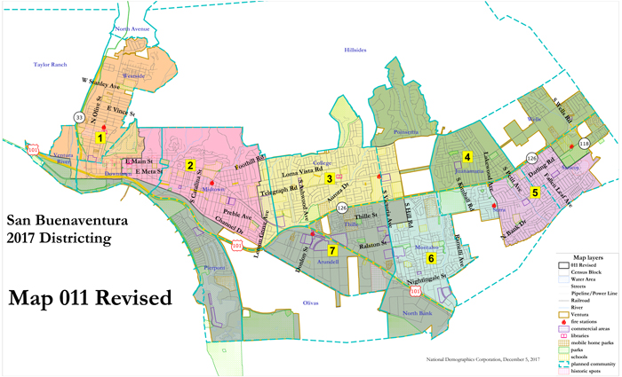
Unanimously, at the December 18 City Council meeting, council members voted 7-0 to adopt an electoral district map for the 2018 and 2020 election cycles, which brings the arduous work to change from an “at large” election process to a district election process almost to a close. All that remains is adoption of the ordinance amending the City’s election codes, which may be done by mid-January. The re-districting project spans nearly four years, begun in 2014, and involved dozens of council meetings, public notices, thousands of hours of community involvement, staff dedication and input from a professional election consultant. From 33 maps initially submitted by individual and community organizers, 19 maps were legally compliant, followed by a further narrowing of the field to four maps that council chose from: 11,16,22,23. These maps can be viewed at: www.cityofventura.ca.gov/DocumentCenter/View/10830.
With no debate, council picked Map #11, based on the common council perspective that this map keeps communities of interest and geography together. Member Christy Weir, who raised her family in Montalvo, said that Map #11 does not divide Montalvo like some of the other maps. “We always thought of Montalvo as Victoria Avenue to Ramelli Avenue, not divided by Johnson Drive, which is what happens with Map #22,” Weir commented. Member Mike Tracy, who introduced the motion to adopt Map #11, stated that it was important for Montalvo and Pierpont to be in the same district, given their shared socioeconomic and community needs. “We need a map that reminds people that, even though council members will represent their own districts, they still come together to support the whole city,” said member Cheryl Heitmann. Heitmann also said that some neighborhoods like Pierpont are thought to have only wealthy homeowners, but in fact have a lot of renters like the Montalvo area. Member Matt LaVere endorsed Map #11 because it provides a strong Westside, Saticoy and Montalvo. “Map #11 achieves bringing the far ends of the City into council chambers,” said member and former mayor Erik Nasarenko.
Despite the vote, many members of the public spoke to oppose Map #11 and support Maps #22 and #23 that, in their view, represented the City’s Latino vote and community diversity best. Most opponents spoke in the name of CA– USE (Central Coast Alliance United for a Sustainable Economy), which focuses on immigrant rights, wage reform and environmental improvement. A teacher with the Ventura Unified School District called Ventura a “wonky L-shaped city” that requires boundaries recognizing demographic similarities. Others spoke of the need to empower disenfranchised blocks of voters, keep the hillsides separate from the working classes and maintain the unique ethnic characteristics of certain neighborhoods. It was argued that Map #11 neglects the predominantly low income, immigrant and renter populations in Montalvo and Saticoy.
In the final evaluation, valid maps had to meet key requirements of the Federal Voting Rights Act (FVRA) and California Voting Rights Act (CVRA). Mayor Neil Andrews thanked the public and staff for exemplary work on this project. The final reading of the new district ordinance is scheduled for the January 8, 2018 council session.
